Xona Wins Air Force Contract
Xona Space Systems has won a $1.2 million Direct to Phase II SBIR U.S. Space Force contract. The company, which is working with the Space Force and the Air Force Research Laboratory, said it successfully demonstrated the capability of low-Earth orbit (LEO) PNT architecture using the Huginn demo satellite. The company is working with the government entities toward a secure LEO PNT architecture leveraging its PULSAR service.
Contact: Xona Space Systems, www.xonaspace.com.
Digital Matter Offers Worldwide Asset Tracking With New GPS Devices
Digital Matter has announced the expansion of its battery-powered IoT asset tracking portfolio with the addition of 4G Cat 1bis and 2G connectivity to enable worldwide asset visibility. The Oyster3 and Remora3 Global GPS devices feature ‘deploy once’ battery life and enable asset tracking and management across most of the world’s cellular networks, the company said.

In addition to GPS, the Remora3 Global features Bluetooth to communicate with nearby Bluetooth tags, sensors and beacons. This enables flexible tagged asset and condition monitoring, including temperature, humidity, impact detection and more, the company said.
Contact: Shay Kettner, Digital Matter, shay@digitalmatter.com, www.digitalmatter.com.
Favendo Rolls Out Modular RTLS Suite
Favendo has launched its Modular RTLS Suite allows to use real-time location data to reduce search times, increase security, improve processes and save money, the company said. The Modular RTLS Suite features a location engine, SDK, viewer, tagger, dashboard and other features.

By integrating partner technologies from Quuppa or Actility/Abeeway, hybrid RTLS solutions can be implemented that provide high flexibility, the company said. In addition to tracking use-cases, Favendo also offers a client-based indoor positioning wayfinding solution.
Contact: Larissa Sedlmeier, Favendo, marketing@favendo.com, www.favendo.com.
PreAct Rolls Out Mojave Lidar
PreAct Technologies has launched its Mojave Lidar low-cost sensor solution for such applications as smart cities, robotics, cargo monitoring, education & university research, building monitoring, patient monitoring, agricultural and others. “We created the sensor to allow companies to monitor volume and movement through high-density point clouds, which gives them the information they need to adjust their services without the ‘creepy’ factor of watching individuals on camera,” said Paul Drysch, PreAct CEO.

PreAct says Mojave is the only flash lidar on the market designed for the non-automotive industry, as well as automotive, applications. The unit costs $350.
Contact: Angela Simoes, for PreAct Technologies, (415) 302-2934, angela@mpublicrelations.com, www.preact-tech.com.
Quectel Announces SC696S LTE Cat4 Smart Module
Quectel Wireless Solutions has launched the SC696S series of multi-mode smart LTE modules equipped with Wi-Fi and Bluetooth capabilities. The modules leverage Qualcomm’s QCOM 0.00 QCM6125 System-on-Chip (SoC) for IoT and Adreno 610 GPU.

The modules support a multi-constellation GNSS receiver. Applications include tax control machines, on-board equipment, robots, smart home devices, industrial handheld equipment, wearables, vending machines and other smart hardware.
Contact: Quectel, media@quectel.com, www.quectel.com.
OGC Seeks Comment on Mapping Standard
The Open Geospatial Consortium (OGC) seeks public comment on the candidate OGC API – Moving Features – Part 1: Core (OGC API – MF) Standard. Comments are due by Aug. 27, 2023. OGC API – MF provides a uniform way to access, communicate, and manage data about moving features across different applications, data providers, and data consumers, OGC said.
Contact: OGC, ogc.org.
Elo GPS Foils Vehicle Theft Attempts
Elo GPS helped a stolen vehicle victim, after being robbed at gunpoint, by sharing the her vehicle’s real-time location with the Wichita Falls (Texas) Police Department. The Elo GPS App keeps drivers connected to their car in real-time, so they’re always aware of where and how their car is being driven, the company said.

In another recent incident in Seattle, a suspected AirBnB Burglar was apprehended because of data provided by the vehicle owner’s Elo GPS account, the company said. Elo GPS, provided by Connected Dealer Services, offers a 24/7 Stolen Recovery Hotline with recovery specialists on standby to guide customers through the stressful reporting and recovery process and help coordinate with law enforcement on their behalf, the company said.
Contact: Elo GPS, www.elogps.com.
ProStar Integrates Mapping Software Into Leica Geosystems’ GPS/GNSS Receivers
ProStar Holdings [MAPPF] has announced its mapping software, PointMan, will be integrated with Leica Geosystems’ GPS/GNSS receivers for GIS asset data collection. The integration allows a data collection solution that captures, records and displays the precise location of underground infrastructure, the company said. The integration means that PointMan now supports Leica Geosystems’ mobile receivers running Android and iOS, including the Zeno FLX100 plus GNSS receiver.
Contact: Kerry Trivers, Leica Geosystems, (770) 326-9500, kerry.trivers@hexagon.com.
Amazfit and Komoot Partner To Offer Routing, Navigation
Amazfit, owned by Zepp Health ZEPP 0.00, now offers routing and navigation connectivity with the outdoor activities app komoot. The company said that its smartwatches now offer GPS and long battery life.

Users of this GPS smartwatch, along with the recently-launched Amazfit Cheetah series of running watches and the brand’s flagship Amazfit GTR 4 and GTS 4 series, are able to download route files from the Zepp App for navigation directly from the display, the company said.
Contact: Amazfit, www.amazfit.com.

Create a FREE ManyMe Account.

The early bird registration deadline is approaching for ION GNSS+ 2023. This year’s technical meeting will take place Sept. 11-15, 2023 at the Hyatt Regency Denver (located adjacent to the Colorado Convention Center). A virtual registration option is available. To save $200 on registration rates for ION GNSS+ 2023, complete your registration by Friday, August 11.
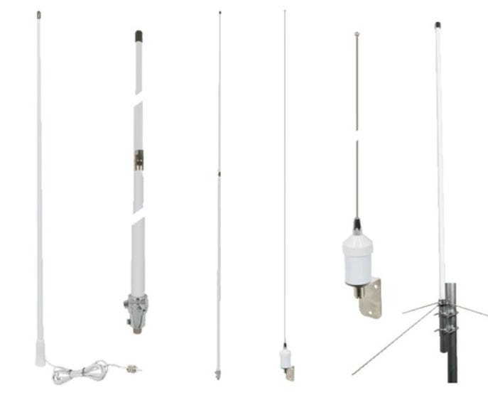
Pasternack Rolls Out Marine Antennas
Pasternack has launched its line of commercial marine-grade ship/boat RF antennas, specifically for the harsh marine environments. GPS capabilities include L1 band and multiband capacities and a gain of 28 dBi, the company said.

Pasternack’s new commercial marine-grade ship/boat RF antennas are in stock and available for same-day shipping.
Contact: Peter McNeil, Pasternack, (978) 682-6936.
InDrive Launches in South Florida
InDrive has announced its official launch in South Florida, the company’s first U.S. market. Known for its bid-based business model, InDrive allows passengers and drivers to negotiate and agree on the price of each ride.

The app has built-in safety features that allow passengers to share trip details with their contacts, with real-time GPS tracking, during rides. InDrive also provides such services as intercity transportation, freight delivery, task assistance, courier delivery and employment search.
Contact: Dakota Orlando, for inDrive, dorlando@5wpr.com, www.indrive.com.
AgEagles Updates UAS
AgEagle Aerial Systems $UAVS has updated its eBee VISION intelligence, surveillance and reconnaissance unmanned aerial systems (UAS) featuring live, 4K resolution video imagery from a distance of up to 12 miles.

Offering up to 90 minutes of flight time, AgEagle’s eBee line can be deployed and operated by a single person. The UAV line now features cursor on target, target tracking, flight planning and GNSS-denied flight mode, the company said.
Contact: AgEagle, media@ageagle.com, www.ageagle.com.

Compliantly hire anyone, anywhere, in 5 minutes with Deel
Deel is your one-stop shop for hiring, paying, and managing your remote team. We stay on top of local labor laws across the world to ensure compliance and mitigate risk so that you don’t have to.
People
- Luminar LAZR 0.00 named Emily Shanklin, formerly of SpaceX, as senior vice president of marketing. The company also named Kevin Hinge, chief supply chain officer at GoPro, as executive vice president of manufacturing, supply chain and quality. Both executives will report to CEO and founder Austin Russell.
- Pointr named Carrie Saarinen as vice president of customer success. Saarinen has worked with SaaS companies since 2012.
- Mike Apperson has been named channel partner executive at GPS Trackit.
- Taoglas has named Leann Lehew as channel partner manager.
Jobs
Open Positions. Cruise.
Careers. Septentrio.
Current Openings. Advanced Navigation.
Customer Success Operations Manager. HERE Technologies.
Technical Project Manager. HERE Technologies.

Your partner in global employment
Over 1000 companies are hiring, paying, and taking care of their team members all over the world with Oyster’s all-in-one global employment platform.

Click HERE to Join our growing Location Business News LinkedIn Group!


