
Send your news releases to kdennehy@driverlessreport.com. Go to www.locationbusinessnews.com for more news and an archive of stories.
Trimble Expands High-Precision GNSS Correction Network Across South America
Trimble TRMB 0.64%↑ has expanded its CenterPoint RTX Fast network correction service across Brazil, Paraguay and Uruguay, delivering near-instant, sub-centimeter GNSS positioning via L-band satellite and IP delivery. The expansion allows operators in agriculture, surveying, civil construction and automotive industries to achieve continuous, high-precision positioning without relying on costly physical base stations, the company said. Powered by a continuously operating reference station network monitored 24/7, the service slashes signal convergence times to as low as one minute across challenging Latin American terrain. The cloud-delivered solution eliminates physical hardware risks like theft, vandalism and weather damage while supporting autonomous field robotics and precision farming.
Contact: Trimble, https://positioningservices.trimble.com/en.
JAVAD GNSS Launches Modular GNSS and Inertial Navigation Line
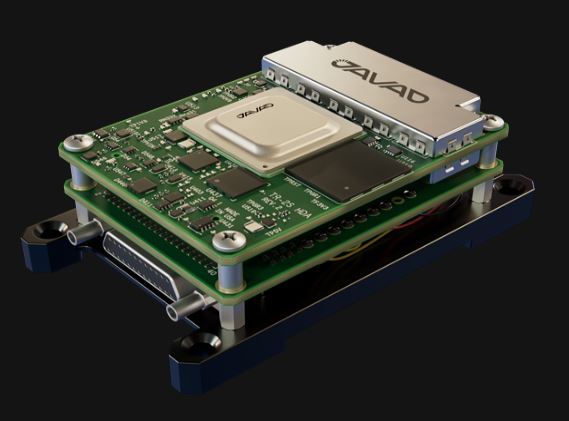
JAVAD GNSS has introduced a new family of tightly integrated GNSS and inertial navigation system (INS) products designed to maintain accurate positioning in contested environments. The new product line pairs the company’s multi-constellation GNSS receivers with commercial and defense-grade inertial measurement units (IMUs) using a custom interface board that manages electrical connections, time synchronization, and data paths.

By delivering continuous position, velocity, and orientation data when satellite signals are jammed, spoofed, or denied, the turnkey systems target demanding applications across aerospace, defense, autonomous vehicles, and robotics. The pre-assembled hardware stack offers integrators a flexible, configurable layout that can be deployed as-is or reconfigured to meet specific platform space constraints, the company said.
Contact: JAVAD GNSS, sales@javad.com, www.javad.com.
HERE Technologies Partners With Octave Intelligence
HERE Technologies has partnered with Octave Intelligence OCTV 0.94%↑ to deliver advanced location intelligence capabilities into Octave OnCall Dispatch, Octave’s computer-aided dispatch solution for incident response operations. The partnership combines Octave’s dispatch and incident management expertise with HERE’s mapping data and location services to help providers respond to incidents faster, operate more efficiently and deliver improved safety outcomes for road users, the company said.

In other company news, HERE and New South Wales Rural Fire Service, the world’s largest volunteer fire service with more than 68,000 volunteers, are demonstrating how advanced location intelligence can help emergency responders navigate more effectively across some of Australia’s most challenging and remote landscapes.
Contact: Vanessa Lee, HERE Technologies, vanessa.lee@here.com.
NovAtel Application Suite Offers Free Data Visualization Tool
All OEM7 receivers come with access to the NovAtel Application Suite as part of managing hardware. Graph is the latest addition to the suite, and empowers users to analyse NovAtel receiver data through interactive plots and mission trajectories, the company said.

Graph includes a Project Wizard with integrated file validation, and a Position Overview to see mission data in context on a geographic map. Users can visualise and compare across time-series plots, including position, velocity, time, heading and attitude, tracking and measurements, and receiver status, the company said.
Contact: Hexagon|Novatel, communications@novatel.com.
Infinite Electronics To Debut Anti-Jamming GNSS Antennas at Commercial UAV Expo
Infinite Electronics has launched a new lineup of Pasternack multi-constellation GNSS antennas featuring advanced anti-jamming technology to support unmanned aerial vehicles in congested environments. Engineered to MIL-STD-810 standards, the ruggedized antennas improve positioning, navigation, and timing performance across multiple global navigation systems and frequency bands.

The hardware features specialized interference mitigation designed to suppress low-elevation jamming sources and reject adjacent-band signal interference, the company said. Infinite Electronics will officially showcase the new antenna series alongside its broader portfolio of RF and microwave components at the Commercial UAV Expo in Las Vegas.
Contact: Infinite Electronics, www.infiniteelectronics.com.

Create a FREE ManyMe Account.
CSafe Launches Mobile Application To Expand Real-Time Cold Chain Visibility
CSafe has launched the CSafe Connect Mobile App, bringing its cloud-based shipment tracking and management capabilities to iOS and Android devices. Designed for pharmaceutical manufacturers, freight forwarders, and airlines, the mobile application allows operational teams to monitor container conditions and real-time GPS locations directly from warehouse floors, tarmacs, and transit hubs.

Users can place and manage lease orders, access shipment data on demand, and receive instant alerts to quickly address potential temperature or location issues in transit. By extending desktop functionality to mobile devices, the tool aims to safeguard sensitive pharmaceutical payloads and reduce the risk of product loss across global supply chains, the company said.
Contact: CSafe Marketing, marketing@csafeglobal.com.
Diesel Laptops and Trucker Path Launch Limited-Time Diagnostic and Navigation Bundle
Diesel Laptops and Trucker Path have launched a joint promotional bundle aimed at reducing operational costs and downtime for truck drivers and small fleet operators. The limited-time offer provides a $100 discount on the Diesel Decoder diagnostic hardware, which connects via Bluetooth to a smartphone to read manufacturer-specific fault codes and perform maintenance commands in under a minute.

The package also includes 30 days of complimentary access to Diesel Repair Professional, providing mobile access to technical repair documents and wiring diagrams. Additionally, users receive a 30-day subscription to Trucker Path Diamond, offering AI-enhanced trip planning, truck-specific GPS routing, and real-time parking availability across North America.
Contact: Trucker Path, www.truckerpath.com.
People
- L3Harris Technologies named Sam Mehta president, CEO, and board member; Lewis Hay III, independent board chair; and Christopher Kubasik stepped down as CEO, chair, and board member after alleged code-of-conduct concerns.;
- The GPS Innovation Alliance endorses the confirmations of Gen. Douglas Schiess as U.S. Space Force Chief of Space Operations; Adam Cassady on his confirmation as U.S. Ambassador-At-Large for Cyberspace and Digital Policy; and Danielle Thumann Severs on her nomination to serve as a FCC commissioner.
- KORE Appoints Roi Ross as Chief Growth Officer to Lead Its Global Growth Strategy.
- Teletrac Navman names Pankaj Sharma vice president of product management.
- Clay Tucker has been named business development manager at Geotab.
- Teletrac Navman Appoints New Vice President of Product Management.
- David McIntosh has been named strategic telecom manager – APAC at Geotab.
Jobs
Chief Operating Officer. Advanced Navigation.
Associate Vice President, EMEA Sales (Remote). Geotab.
Director Sales. Honeywell Aerospace.
Senior Electrical Engineer (HW Design). ANELLO Photonics.
Systems Engineering Director, Resilient Navigation. RTX.
Senior Customer Success Manager. Mappedin.
Director, Enterprise Architecture. HERE Technologies.
Director Applied Science ADAS. TomTom.
Director, Sales and Business Development, Autonomous Platforms and New Mobility. Swift Navigation.
Senior Business Development Consultant. Swift Navigation.
Senior Manager Business Development New Markets. Swift Navigation.
Senior Product Manager, Mobile Ecosystem. Swift Navigation.
Senior Product Marketing Manager, Mobile Ecosystem. Swift Navigation.

Click HERE to Join our growing Location Business News LinkedIn Group!