Send your news releases to kdennehy@driverlessreport.com. Go to www.locationbusinessnews.com for more news and an archive of stories.
Parkopedia and Parkmobile to Launch US eMSP Service, Cuts Deals With ThunderSoft, Neusoft at 2025 Shanghai Auto Show
Parkopedia, recently acquired by EasyPark Group, has announced that sister brand ParkMobile will launch as an eMobility Service Provider (eMSP) in North America. The EV charging service will be powered by Parkopedia, complementing ParkMobile’s existing parking platform for its 65-million user base, the company said.
In China, Parkopedia and ThunderSoft announced, at the 2025 Shanghai Auto Show, that they will combine their connected car services, in-car payment and intelligent operating system expertise. Specifically, the deal integrates Parkopedia’s parking and charging into ThunderSoft’s Aqua OS vehicle operating system.

In other company news, Parkopedia has signed a memorandum of cooperation with Neusoft to integrate its latest OneCoreGo Global In-Vehicle Intelligent Mobility Solution 6.0 with Parkopedia’s mobility services for international markets.
Contact: Adam Calland, Parkopedia, 44 (0)7838 219129, adam.calland@parkopedia.com.
NAL Research and VectorNav Integrating Tech into Iridium INS Solution
NAL Research and VectorNav Technologies have announced a joint development to produce Iridium IRDM -0.21%↓ STL-aided Inertial Navigation Systems to meet the demand for resilient PNT in GNSS-denied environments. The companies, exhibiting at SOF Week Exposition May 5–8, say NAL’s APNT receivers are integrated with Iridium STL service, which leverages a Low-Earth Orbit (LEO) transmitted signal approximately 1,000 times stronger than traditional GNSS.

VectorNav is leveraging its VN-210E GNSS-Aided INS, which combines a tactical-grade IMU with an L1/L2 GNSS receiver in a miniature, board-mount package. It integrates with NAL Research’s ALTM Gen2 Mini Iridium STL receiver.
Contact: Kaelyn Banks, NAL Research, kbanks@nalresearch.com; Zane Woodson, VectorNav Technologies, woodson@vectornav.com.
PTx Trimble Launches NAV-960 GNSS receiver for Precision Autoguidance
PTx Trimble has released its NAV-960, an update to the company’s previous solution. The new update increases the unit’s speed, processing power and accurate positioning for farming operations, the company said.

The NAV-960 comes standard with company displays and steering systems. In addition, according to PTx Trimble, unit has upgraded GNSS sensors for centimeter-accuracy upgrades.
Contact: PTx Trimble, www.ptxtrimble.com.
One Step GPS Wins Stevie Award
San Fernando, Calif.-based One Step GPS recently won a Gold Stevie Award in the category of Customer Service Department of the year. The Stevie Awards are determined by the average scores of more than 250 professionals worldwide in the three-month judging process. The awards program receives more than 12,000 nominations per year.
Contact: Adam Ben Jacob, One Step GPS, adam@onestepgps.com, (818) 659-2032, www.onestepgps.com.
Globalstar Launches Two-Way Satellite IoT Solution
Globalstar GSAT 2.39%↑ announced the launch of a new two-way satellite Internet of Things (IoT) solution using its low-Earth orbit (LEO) constellation. The new platform offers low-power communication with assured delivery and low-latency messaging for applications like fleet and asset tracking. Globalstar’s RM200M module integrates GNSS, Bluetooth, an accelerometer, and an application processor.
Contact: Alisa Moloney, alisa.moloney@globalstar.com, www.globalstar.com.
UP42 and Maxar Partner to Broaden Access to Geospatial Intelligence
UP42 has partnered with Maxar to make Maxar’s satellite imagery and tasking products available on its platform. Maxar’s constellation has the capability to revisit Earth locations up to 15 times per day, the company said. UP42 customers will be able to order 30 centimeter-class and 50 centimeter-class imagery from Maxar’s archive, the company said.
Contact: Dobrina Laleva, UP42, dobrina.laleva@up42.com, https://up42.com/marketplace/data/tasking/maxar-tasking.

Create a FREE ManyMe Account.
Ondas Receives $3.4 Million Order for Anti-Drone System
Ondas Holdings announced it secured a $3.4 million order for its Iron Drone Raider counter-unmanned aerial system (C-UAS). The order comes from a well-known European defense contractor and is intended for a government client, the company said.

Iron Drone Raider is designed to detect, track, and mitigate drone threats. The system will be deployed to address the increasing need for counter-drone capabilities.
Contact: Preston Grimes, Ondas Holdings, preston.grimes@ondas.com.
A2MAC1, Gasgoo Partner for Automotive Data Services
A2MAC1 and Gasgoo announced a global partnership to explore new automotive intelligence services, enhancing both companies’ growth strategies, the company said. The collaboration aims to leverage their expertise to better respond to market expectations, including cost, CO2 calculations, and supply chain knowledge, and to create joint value for customers. The new business offering is planned to launch in July 2025.
Contact: A2MAC1, communication@a2mac1.com, www.a2mac1.com.
EliseAI Integrates Engrain Data for Enhanced AI Apartment Tours
EliseAI has partnered with Engrain to integrate Engrain’s SightMap and TouchTour data into its AI Guided Tours product. The integration will incorporate Engrain’s SightMap and TouchTour data, providing prospective renters with more detailed and interactive property information during virtual tours, the company said.
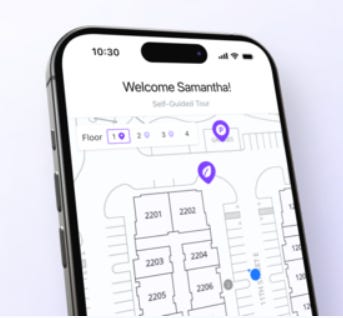
Leveraging GPS tracking, users can view their real-time location directly overlaid onto dynamic property maps, ensuring seamless navigation and eliminating the risk of getting lost, the company said. The maps reflect unit availability and allow renters to explore multiple floors, view photos, and access detailed apartment information as they tour, the company said.
Contact: Arianna Paranzino, EliseAI, (408) 892-9207, press@eliseai.com.
AgEagle Launches Drone Software Enabling Navigation Without GPS
AgEagle Aerial Systems has announced the release of its next-generation eBee VISION application software, featuring a key update allowing for autonomous position updates using map referencing in areas where GPS signals are unreliable or unavailable. This advancement enables continuous drone navigation for military, public safety, and industrial users in GNSS-denied environments, according to the company. The software also includes features like optical flow stabilization, improved ground detection, and optimized cruise speed in windy conditions, the company said.
Contact: AEagle Aerial Sytems, uavs@ageagle.com, www.ageagle.com.

Click HERE to Join our growing Location Business News LinkedIn Group!


