


DENVER—The Geo Week conference here featured most GNSS, lidar and other location companies who are trying to grab a larger share of the uncrewed systems market, particularly for survey and mapping applications. Organizers say the conference, once held in a nearby hotel and then seen as a drone tech show, has grown to 3,000 attendees and a sold-out exhibit hall at the Colorado Convention Center.

One company, California-based Looq AI, offered its Q camera that integrates Septentrio’s mosaic-X5 GNSS module receiver to offer centimeter-grade PPK accuracy for survey-grade 3D modeling. The handheld Q creates a digital twin of to modernize asset management, infrastructure maintenance, surveying and other applications, said CEO and co-founder Dominique Meyer.

“With 3D modeling, we are serving companies quickly with analysis, whether that’s creating bathymetric surveys or overhead. Accuracy is paramount, so we integrated GNSS modules, out of the box, for survey,” he said. “I see this market loaded with lidar systems, but we have to think out further, how do we save companies more money and time?”
The mosaic receiver is integrated with INS and four cameras, which captures data needed for a georeferenced 3D model of the environment. Looq AI believes the end result is 100 times the data rates and spatial sampling compared to a laser system.

San Francisco-based Point One Navigation, which exhibited at Geo Week, said that in mid-2024 they finished a virtual network of more than 950 base stations to offer true RTK. “We now have 70 percent of the U.S. land mass coverage. We are working on L-band in beta with a few customers,” said Chris Dima, Point One’s director of growth. “We have been growing in the utility space—and we’re shipping a lot of base stations. One service company has switched from GPS to RTK in one fell swoop for more than 500 licenses.”
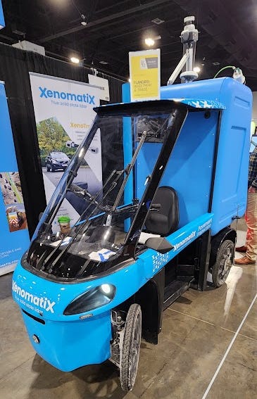
In Geo Week product rollouts:
- Xenomatix’ new XenoBike, a four-wheel electric bike, is equipped with sensors for pavement inspection. It features lidar, cameras, and GNSS.
XenoBike - Leica Geosystems, part of Hexagon, announced an airborne hydrographic mapping unit, Leica CoastalMapper. Designed for shallow to deep-water surveys, the lidar sensor increases collection efficiency by 250 percent compared to previous generations, the company said. CoastalMapper integrates a bathymetric lidar module with a Leica TerrainMapper-3 topographic lidar and imaging into a lightweight sensor head, the company said.


- Topcon Positioning Systems partnered with Pix4D to combine geopositioning and photogrammetry solutions. Topcon will become an authorized distributor of Pix4D’s photogrammetry software portfolio. This allows greater customer access to positioning and 3D mapping technologies, the company said.
- CompassData celebrated its 30th anniversary at Geo Week. The company highlight its ISO and FAA and made three presentations at the conference. CompassData’s main offering is its archive of 80,000 photo-identifiable GCPs collected in more than 100 countries.


