Geo Week 2024 Offers New Industry Products and Applications
Geo Week 2024 in Denver this week offered several industry panels on drones, survey, lidar, mapping and other topics. It is also becoming a strong conference for launching mapping, survey and drone products…
Geo Week press releases:
- Inaugural World Lidar Day Launched.
- Trimble and DroneDeploy Collaborate.
- Introducing GeoSpatial Manager by Maptek
- SCANFLY v3: The Mobile Mapper
- Unveiling Compact Handheld Scanner at Geo Week 2024: XGRIDS Revolutionizes 3D Scanning with Lixel Series Products
- Inertial Labs Unveils the new GEN-II RESEPI scanning and mapping solution
- Capturing Tomorrow: FJDynamics Reveals New 150MP Aerial Mapping Camera at Geo Week 2024
- Mosaic Xplor: Backpack Camera + LiDAR
- Teledyne Geospatial revolutionizes airborne lidar ROI with Galaxy Onboard: a real-time workflow solution
- Integration of Mosaic’s High Resolution 360º Camera with Laser Scanning Solutions
- CHC Navigation Multi-platform, high-accuracy 3D laser scanning solutions for geospatial and mapping professionals
- DJI M300 Mapping Payload from Klau Geomatics
- AlphaAir 450 LiDAR System is the lightest, most accurate and cost-effective UAV LiDAR system in its class
- BAAM.Tech Named North American Reseller for AISPECO’s Next-Generation Infrastructure Inspection Platform
- Esri Releases New ArcGIS Reality Software to Capture the World in 3D
HERE Achieves AWS Automotive Competency
HERE Technologies has achieved the Amazon Web Services (AWS) Automotive Competency. The specialization tags HERE for its expertise in providing customers with professional services in Advance Driver Assistance System (ADAS), autonomous vehicle, connected mobility, digital customer engagement, sustainability, electric vehicle, supply chain, and software defined vehicle strategic workloads, the company said.

To receive the AWS Automotive Competency designation, AWS Partners must undergo a rigorous technical validation and provide vetted customer references, the company said. This is the third AWS Competency designation HERE has received, having previously received the AWS Supply Chain Competency and AWS Public Sector/Disaster Response Software Competency, the company said.
Contact: Reed Findlay, HERE Technologies, (703) 966-6284,
Reed.findlay@here.com, www.here.com.
Link Labs’ AirFinder Solution Now on the Geotab Marketplace
Link Labs‘ AirFinder Everywhere solution for trailer tracking and logistics visibility is now available on the Geotab Marketplace, the company said. AirFinder Everywhere solution is designed to provide visibility for a logistics company’s non-powered assets. It is designed to integrate with telematics and supply chain management systems to provide new sources of data, the company said.
Contact: Link Labs, www.link-labs.com.
Farnell Announces New Distribution Partner Agreement With Taoglas
Farnell has announced a distribution agreement with Taoglas that allows the company to offer customers an expanded RF and wireless product offering. Farnell and its global brands, Newark and element14, offer products North America, Europe, and Asia.

Taoglas’ offers antennas and RF components covering cellular, GPS/GNSS, Wi-Fi, Bluetooth, UWB, NFC/RFID, LPWA, ISM band, and satcom applications.
Contact: Taoglas, www.taoglas.com.
Appdome Launches Geo Compliance Feature Set
Appdome rolled out its Geo Compliance feature set, allowing mobile brands to trust the user’s location and detect location spoofing, fake GPS apps, VPN use, SIM swaps and other methods used to circumvent geo restrictions in mobile applications. Mobile brands can combine Appdome’s new, no-code, no-SDK, Geo Compliance features with any other mobile app defense features on its unified mobile app defense platform, the company said.
Contact: Appdome, www.appdome.com/geo-compliance.
Exyn Rolls Out Nexys 3D Mapping Solution
Exyn Technologies has launched Nexys, a modular 3D mapping solution. The product is designed for the mining, construction, AEC, and geospatial industries.
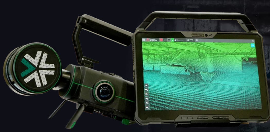
Nexys is equipped with lidar, proprietary SLAM algorithms and can operate in GPS-denied settings. Nexys includes GPS modules, protective cages, and Drone Link for robot integration, the company said.
Contact: Exyn Technologies, www.exyn.com.
Woolpert Invests in Leica Geosystem’s Pegasus
Woolpert has invested in Leica Geosystem’s Leica Pegasus TRK700 Neo to augment its geospatial data collection capabilities. This new mobile mapping system will be used to conduct aviation and transportation infrastructure surveys to support asset management and inventories, statewide GIS solicitations, and other state department of transportation needs. The TRK700 Neo uses a combination of high-precision GNSS positioning, inertial measurement units, and lidar data to generate accurate 3D point clouds of the surrounding environment, the company said.
Contact: Woolpert, woolpert.com.

Create a FREE ManyMe Account.
FarmX Presents Autonomous Navigation Without GPS
FarmX has launched its Perceptive Navigation vehicle autonomy in demonstrations at the 2024 World Ag Expo. FarmX offers autonomous vehicle navigation without GPS or connectivity on vehicles equipped with Perceptive Navigation, the company said.
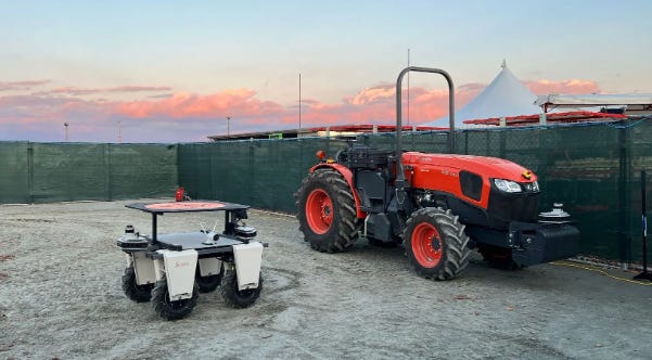
Unlike traditional GPS-dependent systems, FarmX’s robotics platform allows navigation in complex agricultural environments such as dense foliage, mountainous terrain, adverse weather, and low-visibility scenarios, the company said. The platform can be licensed for tractors, rovers (UTVs, ATVs) and drones.
Contact: Sarah Levin, FarmX, sarah@farmx.ag, www.farmx.ag.
Capella Space Partners With TCarta
Capella Space has announced a partnership with TCarta to add high-resolution SAR satellite imagery to TCarta’s coastal monitoring and shoreline feature extraction solutions. This partnership will allow identification of coastline changes, so coastal managers have the accurate and up-to-date information for mitigating the impacts of climate change, the company said. TCarta’s technology will leverage Capella’s automated satellite tasking system to synchronize SAR imagery collections to match up with real time tidal fluctuations, the company said.
Contact: Capella Space, www.capellaspace.com.
Fairview Microwave Rolls Out Military-Grade Antennas
Fairview Microwave has launched military-grade antennas that include ruggedized GPS, manpack omni, and vehicle omni antennas. Fairview’s military-grade antennas meet MIL-STD-810 standards, the company said.

In addition, the antennas are TAA-compliant (Trade Agreements Act), making them suitable for government and defense applications where compliance is non-negotiable, the company said.
Contact: Fairview Microwave, (972) 649-6678, infiniteelectronics.com.
Latest Surfer Mapping and 3D Visualization Package from Golden Software
Golden Software has enhanced the 3D visualization capabilities of its Surfer mapping and 3D visualization software, the company said. The expanded visualization tools make it easier to create 3D grid files for the viewing and analysis of drillhole data, the company said.
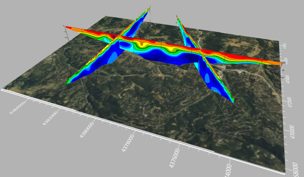
More than 100,000 people use Surfer worldwide, many of which are involved in environmental consulting, water resources, engineering, mining, oil & gas exploration, and geospatial projects, the company said.
Contact: Golden Software, (303) 279-1021, www.goldensoftware.com.
People
- Cruise LLC has announced it has hired automotive safety leader Steve Kenner as its Chief Safety Officer.
- LandAirSea Systems, which designs and builds GPS tracking technology for fleet management, has appointed Hall of Fame NFL wide receiver Cris Carter to its board of directors.
- Maxar appointed Arvind Srinivasan as CTO.
- CompassData has appointed Kate Schlatter as CEO,
- Marius Swanepoel has been appointed director maps – Map Experts at TomTom.
- Hamdy Elsayed, innovation manager at Teledyne Geospatial, has been named “Robert E. Altenhofen Memorial Award” recipient at Geo Week in Denver.
- Furqan Ahmed has been been named senior GNSS scientist at TrustPoint.
Jobs
Regional Marketing Manager (APAC, Japan based). TomTom.
Sr. Product Manager – Autonomous Driving. TomTom.
Senior Vice President Information Technology. Orbcomm.
Site Reliability Engineer. Point One Navigation.
Proposal Manager – Hybrid/Remote. Woolpert.
Head of System Product Development. CrossInt (Septentrio).
Sr. Analyst/Manager– Business Operations. Mobilisights.
Senior Account Executive. Airspace Link.

Click HERE to Join our growing Location Business News LinkedIn Group!
