Swift Navigation Launches Partner Program
Swift Navigation has launched its Swift Partner Program that includes mobile network operators (MNOs), chipset and module manufacturers, system integrators, and application platform providers. With the launch of its Partner Program, the company said it is simplifying the process to enable precise location and deliver user experiences in any geography, scale and unit economics. Swift is offering partners its Skylark Precise Positioning Service that delivers centimeter-accurate positioning through carrier-grade networks, the company said.
Contact: Swift Navigation, www.swiftnav.com/partners.
What3words Partners With Aston Martin
What3words has partnered with Aston Martin to bring its location technology to the DB12. The technology will première in the new DB12 as part of a new Aston Martin infotainment system.

What3words has divided the globe into a grid of 3m x 3m squares, and given each one a unique combination of three words. This precludes difficulties in navigating to specific building entrances, those without addresses and secluded residences, the company says. Both the DB12’s navigation system and the new Aston Martin connected app will feature what3words destination input.
Contact: What3words, prteam@what3words.com.
Point One Joins STMicroelectronics Partner Program
Point One Navigation has joined the STMicroelectronics Partner Program to deliver navigation and positioning solutions for ST customers in the United States and Western Europe. Developers have a quicker path to create navigation systems by using ST Teseo GNSS Solutions, which include Point One’s API software and RTK network, the company said.

Applications include agriculture, construction, last-mile delivery, and even autonomous vehicles such as cars, trucks and robo-taxis. The partner program includes Point One’s Polaris Cloud that enables high-precision GPS and computer-based localization, the company said.
Contact: Mark Shapiro, for Point One Navigation, (619) 249- 7742, mshapiro@srs-techpr.com, www.pointonenav.com.
U-blox Cellular IoT Modules Certified
Thalwil, Switzerland-based u-blox [UBXN] has announced that its LARA-R6 LTE Cat 1 and LARA-L6 LTE Cat 4 cellular module series have become the first in the market to be successfully tested to comply with the RED article 3.3 d/e/f requirements. This testing used the ETSI EN 303 645 standard and helped the company to achieve RED cybersecurity certification.

U-blox said it is the first module maker in the market to have its LTE Cat 1 and LTE Cat 4 cellular modules certified by the European Union‘s Cybersecurity Certification.
Contact: Natacha Seitz, u-blox, 41 76 436 0788, natacha.seitz@u-blox.com.
GMV Partners With BMW Group for Positioning Technology
GMV has been chosen by BMW Group to provide positioning technology for automated driving. GMV’s positioning solution has two components–an onboard Positioning Engine software and a GNSS Corrections Service providing the vehicles with corrections to the Broadcast GNSS Ephemeris, the company said.

GMV offers its precise positioning solution, GMV GSharp, for automotive that provides accuracy, safe and reliable positioning information (position, velocity, and heading), the company said.
Contact: GMV, marketing@gmv.com, www.gmv.com.
Trimble Opens Labs, Makes Donation
Trimble TRMB -1.86%↓ and The Ohio State University have announced the opening of two labs for the College of Food, Agricultural, and Environmental Sciences (CFAES). The two new Trimble Technology Labs provide students with access to agriculture and construction technologies used today by professionals in the industry, the company said.
In other company news, Trimble announced a donation of $100,000 to World Food Program USA’s corporate partner program, ERASE HUNGER, raising funds in support of the United Nations World Food Program (WFP)’s school meals program around the world.
Contact: Trimble, www.trimble.com.
Geotab Launches Order Now in Australia with Sensata INSIGHTS
Geotab has announced the launch of the Geotab Marketplace Order Now program in Australia featuring Sensata INSIGHTS as its first participating partner. Order Now allows customers to order solutions from the Geotab Marketplace ecosystem.

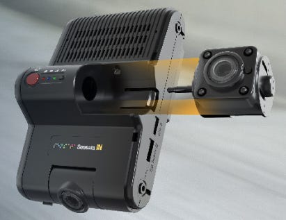
The Sensata KP2 is a modular HD road-facing dash cam that offers road and optional driver-facing visibility and features an advanced driver-assistance system (ADAS).
Contact: Hanna Corrente, pr@geotab.com, www.geotab.com.
BlackSky Wins Air Force Research Contract to Track Vehicles in Real Time from Space
BlackSky Technology BKSY 0.00%↑ has won a U.S. Air Force Research Laboratory AFWERX Direct to Phase 2 contract. The contract, funded by the Space Development Agency, is to build an automated target recognition service that will gather and combine radio frequency and electro-optical satellite sensor data to track mobile assets.

In turn, the secure information will be securely distributed to remote devices and analysts worldwide, the company said.
Contact: Pauly Cabellon, BlackSky, pcabellon@blacksky.com, www.blacksky.com.
Pole Star Global Acquires StratumFive Group
Pole Star Global has acquired maritime tech company StratumFive. The company’s Podium5 features fleet monitoring, regulatory compliance, performance analytics and voyage optimization. The combination expands Pole Star’s industry fleet coverage and complements its vessel compliance and tracking solutions, with PurpleTRAC and MDA, the company said.
Contact: Pole Star Global, pr@polestarglobal.com, www.polestarglobal.com.

Create a FREE ManyMe Account.
Lytx Expands AI-Powered Geospatial Solutions
Lytx has announced its Weather Hazard Alerts, available to all clients as a project within the Lytx Lab tab in their accounts. The AI-powered geospatial technology, built on the Lytx Vision Platform, was developed within Lytx Lab, the company said.

Weather Hazard Alerts overlays NOAA weather warnings onto fleet maps, allowing managers to set alerts based on specific geographic, timeframe, and weather criteria, the company said. The Weather Hazard Alerts feature is available now to all fleet managers within the U.S. Lytx network, the company said.
Contact: Jason Andersen, Lytx, corpcomm@lytx.com, www.lytx.com.
Europe and North America Reached 30.4 Million Insurance Telematics Policies
Berg Insight says that European insurance telematics policies reached 13.6 million in 2022’s 4th quarter. Growing at a compound annual growth rate (CAGR) of 8.9 percent, this number is expected to reach 20.7 million by 2027. In North America, the number of insurance telematics policies is expected to grow at a CAGR of 11.7 percent from 16.8 million in 2022 to 29.2 million in 2027. The United States, Italy, United Kingdom and Canada are still the largest markets in terms of insurance telematics policies, the company said.
Contact: Johan Fagerberg, Berg Insight, 46 31 711 30 91, johan.fagerberg@berginsight.com.
RedSOS Survey Says 60 Percent of Americans Feel Unsafe
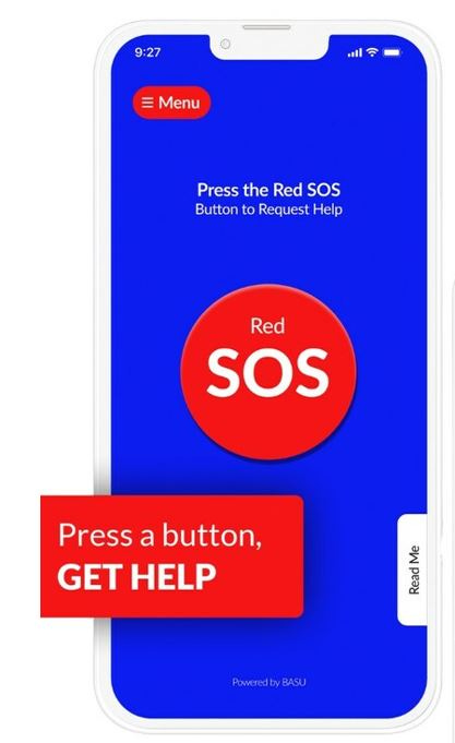
A RedSOS survey reveals that 6 out of 10 Americans feel unsafe on a daily basis. To help reduce this stress, RedSOS offers 24/7 private emergency assistance on their mobile app that features a GPS link for location.

First responders can be notified of a user’s emergency after the RedSOS’s emergency response center is notified, the company said. Friends and family also received GPS location at the same time.
Contact: RedSOS, www.redsos.com
Netradyne Launches Driveri One
Netradyne has launched of its Driveri One video telematics device that uses Geotab’s analytics platform and user interface. The solution features fleet tracking capabilities, with visibility into trips and activity. Near real-time GPS tracking allows customers to select areas on the map to create zones that trigger notifications when a vehicle enters and leaves the location, the company said.
Contact: Sarah Duckett, Netradyne, (415) 519-4161, sarah.duckett@netradyne.com, www.netradyne.com.
Road Ready Trailer Telematics Offered as Option on MAC Liquid Tank Trailers
Road Ready and MAC Liquid Tank Trailers have agreed to offer Road Ready advanced trailer telematics as a factory-installed option on MAC LTT trailers. Road Ready trailer telematics solutions require the installation of a proprietary telematics device named the Road Ready Master Control Unit, the company said.

Fleets can customize how often each asset communicates its location status, the company said. Fleets can set up custom landmarks to create geofences for established routes, triggering alerts to help fleets protect their assets and customer cargo, the company said.
Contact: Mark Johnson, Clarience Technologies, (312) 375-4964, mjohnson@clariencetechnologies.com, www.roadready.com.
VHC Health Signs Multi-Year Renewal of With Phunware
Phunware PHUN -2.01%↓ has announced a five-year contract renewal to license its digital front door and location-based services to VHC Health. The company’s digital front door features wayfinding to help navigate VHC Health’s main campus and parking location, among others.
Contact: Phunware, (512) 693-4199, press@phunware.com.
Nauto Launches Telematics Solution Capabilities
Nauto has announced new telematics capabilities for its vehicle safetly solution that includes vehicle tracking, utilization, misuse and maintenance planning. Nauto’s solution offers AI-powered driver and vehicle safety capabilities, on a single device and a single software platform, the company said.
Contact: Nauto, www.nauto.com.
Chat with your enterprise databases using secure generative AI and empower business users in your team to do their own data analyses in seconds.
People
- Garmin GRMN -1.12%↓ announced that co-founders Min Kao and the late Gary Burrell have been named to the National Aviation Hall of Fame (NAHF).

- Aaron Thompson has joined Trimble Autonomy TRMB -1.86%↓ as the vice president of research and development.
Jobs
Mid-Market Sales Account Executive. Azuga.
Contract Content Writer. Point One Navigation.
Regional Sales Manager- Americas. Trimble.
Field Marketing Manager. CameraMatics.
Senior Legal Counsel. Placer.ai.
Job Openings. u-blox.

Click HERE to Join our growing Location Business News LinkedIn Group!


