EUSPA Releases 2024 EO and GNSS Market Report
The EU Agency for the Space Program has rolled out its 2024 Earth Observation and GNSS Market Report. The free 224-page market report, which is updated every two years, features a general overview of the EO and GNSS market. It includes applications, market size and revenues.
Contact: EUSPA, www.euspa.europa.eu/european-space/euspace-market/gnss-market/eo-gnss-market-report.
Point One Navigation’s Polaris RTK Tech Working With Civ Robotics
Point One Navigation’s new case study features its Polaris RTK technology that is working with Civ Robotics for construction layout. Civ was able to plug-and-go with Polaris RTK, without having to set up and calibrate expensive base stations, the company said.

Leveraging Polaris Real-Time Kinematics Network (RTK), Civ’s robot rovers can translate construction plans to real-world layout markings that are accurate to within less than a centimeter, the company said.
Contact: Mark Shapiro, for Point One Navigation, (619) 249-7742,
mshapiro@pointonenav.com, www.pointonenav.com.
Digital Matter Selects Ubilite Indoor Location Products
Digital Matter has selected Ublite for its Wi-Fi indoor location products. The Ubilite’s UBI206 Wi-Fi chip removes the tradeoff between high-data rate application experience and power consumption, the company said. The UBI206 is a single die (SOC) that enables a number of IoT products with minimal number of external components, the company said.
Contact: Clint Brown, Ubilite, cbrown@ubilite.com.
DriverPro On Jamf Marketplace
Driver Technologies has launched DriverPro on the Jamf Marketplace. The integration of DriverPro will provide Jamf users with the ability to leverage employees’ managed devices to deploy the Driver app, which will automatically detect when an employee starts to drive and collect location, speed, g-force, weather and telematics events, the company said. This data is then uploaded to the Driver Cloud, providing coverage of the fleet to track vehicles in real time and view aggregated driving behavior analytics, the company said.
Contact: Maddie Hirsch, for Driver Technologies, driver@calibercorporateadvisers.com, drivertechnologies.com.
Teledyne Geospatial to Introduce Optech’s CL-360 Marine Scanner at Oceanology Conference
Teledyne Geospatial will introduce the Optech CL-360 Marine long-range laser scanner at Oceanology International in London on March 12. The scanner features a scan speed of 250 lines per second with 2 mm range resolution, the company said.

The CL-360 Marine is the only lidar system designed for use on an uncrewed surface vessel (USV) that provides survey grade range and accuracy, the company said.
Contact: Jennifer Parham, Teledyne Geospatial, Jennifer.Parham@teledyne.com
Soracom and Suzuki Agree to IoT Mobility Partnership
Soracom and Suzuki Motor Corp. have partner on IoT mobility services that provide infrastructure for business, including automotive manufacturers. Potential focus areas for the partnership’s IoT technologies include electric vehicles, modular base units and new technologies and services.
Contact: Justine Schneider, for Soracom, jschneider@calysto.com, (404) 266-2060, ext. 507, www.soracom.io.
Leica Geosystems Unveils Leica TerrainMapper-3
Leica Geosystems has rolled out the TerrainMapper-3 airborne lidar sensor, featuring new scan pattern configurability. TerrainMapper-3 provides three scan patterns to customize the sensor’s performance to specific applications, the company said.

Circle scan patterns enhance 3D modelling of urban areas or steep terrains, while ellipse scan patterns optimize data capture for more traditional mapping applications, the company said. The sensor’s higher scan rate allows customers to fly the aircraft faster while maintaining data quality, the company said
Contact: Cristina Mauri, Leica Geosystems AG, cristina.mauri@hexagon.com, www.hexagon.com.
Coast Guard Announces Antennas Phase Center Offsets, WGS 84 Update
The U.S. Space Force has publicized the Antenna Phase Center Offsets of the L1, L2
and L5 signals for the Earth Coverage (EC) antenna deck, as well as the Timing Group Delay (TGD) and inter-signal correction (ISC) values as measured at the factory for GPS-III SVN-79. The data can be found on the GPS Technical References page of the U.S. Coast Guard Navigation Center: GPS Technical References | Navigation Center (uscg.gov). In other CGSIC news, the Space Force’s 2d Space Operations Squadron (2 SOPS) and the National Geospatial Intelligence Agency‘s Global Navigation Satellite System Division (SFNG) worked collaboratively to deliver an updated WGS 84 reference frame to worldwide users of GPS.
Contact: Rick Hamilton, U.S. Coast Guard Navigation Center, (703) 313-5930.

Create a FREE ManyMe Account.
Spire Launches Four Satellites on SpaceX
Spire Global SPIR 8.81%↑ launched four satellites on the SpaceX Transporter-10 mission. Spire built and launched two satellites for IoT company Myriota. These satellites will also join Spire’s constellation, contributing to the collection of data for Automatic Dependent Surveillance-Broadcast (ADS-B), the company said.
Contact: Sarah Freeman, Spire, sarah.freeman@spire.com, spire.com.
Abracon Releases GNSS RF Antennas
Abracon has launched a new line of GNSS antennas, which feature fast signal acquisition for location-based services, the company said. The new GNSS antennas support L1/L2/L5 + L band data correction services.
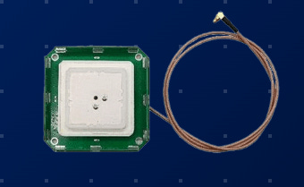
Some use cases include aerospace and defense, location tracking for customers valuable assets, and mapping accuracy for geolocation, precision agriculture, and industrial IoT, the company said.
Contact: Abracon, (512) 371-6159, www.abracon.com.
Sanborn Enhances Image Analyst
The Sanborn Map Co. has launched an enhanced version of its Image Analyst, a web-based imagery data review application accessible through the company’s GeoServe platform. This upgraded application transforms and streamlines the geospatial data review process, the company said.
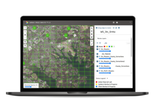
Key features of the updated Image Analyst include efficient real-time collaboration, allowing multiple users to review data simultaneously, view each other’s comments in real time, and expedite the review process, the company said. Enhanced metadata facilitates issue spotting and resolution, with information on QAQC calls enabling the tracking of active participants and quick identification of patterns and common issues, the company said.
Contact: Tom Harrington, The Sanborn Map Co., tharrington@sanborn.com
GeoComm Indoor Maps Integrated With RapidSOS Premium
GeoComm and RapidSOS have announced the integration of GeoComm Indoor Maps into RapidSOS premium. RapidSOS Premium provides public safety agencies with one unified mapping solution to deliver NG9-1-1 data and solutions, the company said. The integration of indoor maps, using Esri technology, allows emergency call takers and first responders with location information, the company said.
In other company news, GeoComm and ELi Technology, provider of the Emergency Mobile Location (EML), have partnered on a new location service, known as ATLS, driven to enhance school safety, the company said.
Contact: GeoComm, www.geocomm.com.
Nordic Rolls Out LTE-M/NB-IoT SiP Module
Nordic Semiconductor has launched the nRF9151 SiP module, which adds to the nRF91 cellular IoT lineup. The new module includes a 64MHz Arm Cortex-M33 SoC, LTE-M/NB-IoT connectivity with a radio-frequency front-end (RFE) for cellular support, and DECT NR+ connectivity, the company said.

The Nordic nRF9161 SiP module also designed to power cellular IoT and non-cellular 5G solutions that was introduced just last month, the company said. The module features a built-in GNSS receiver and cellular-based location features.
Contact: Nordic Semiconductor, www.nordicsemi.com.
People
- TomTom [TOM2] has announced that Maaike Schipperheijn has been nominated for appointment to its board for four years, effective in April 2024.
- Ericsson ERIC 0.36%↑ has announced that Rebecca Rohr, currently head of corporate and government investigations, will become chief compliance officer
- Combain Mobile AB has named Fredrik Beckman as vice president of marketing.
- Linxup has appointed Steven Diogo as vice president of marketing.
- Grainne Woods has been named senior marketing communications program manager at Trimble.
- Mohamed Tamazin has been named GNSS engineering manager within the R&D GNSS Simulation Engineering team at Safran – Navigation & Timing.
Jobs
Partner Account Manager II. HERE Technologies.
Internal Communications Expert. TomTom.
Automotive Customer Program Manager. Swift Navigation.
Research Engineer (GNSS). Rx Networks.

Click HERE to Join our growing Location Business News LinkedIn Group!


