Send your news releases to kdennehy@driverlessreport.com. Go to www.locationbusinessnews.com for more news and an archive of stories.
Thalwil, Switzerland-based u-blox has launched PointPerfect Global, a new GNSS correction service designed to deliver high-precision positioning worldwide. The company said it will cater to applications such as precision agriculture, UAV-based mapping, and autonomous robotics.

PointPerfect Global aims to provide sub-decimeter positioning accuracy, even in remote locations, using both internet and L-band satellite broadcast, the company said. The company said the service is optimized for its ZED-X20P GNSS receiver, which will be the first to support PointPerfect Global with integrated L-band support. The company plans to begin early access to PointPerfect Global in late 2025, with general availability expected in the first half of 2026.
Contact: Sven Etzold, u-blox, 41 76 561 0066, sven.etzold@u-blox.com.
Winnebago, KORE Launch Connected RV Platform
KORE KORE 0.00%↑, Robo ROBO 0.00%↑, Ericsson ERIC 0.00%↑, and Winnebago WGO 0.00%↑ have collaborated to launch Winnebago Connect, a platform that integrates IoT technology to enhance the recreational vehicle (RV) experience. KORE’s IoT solutions provide global connectivity, Robo delivers the software for the user interface, and Ericsson supplies network solutions.
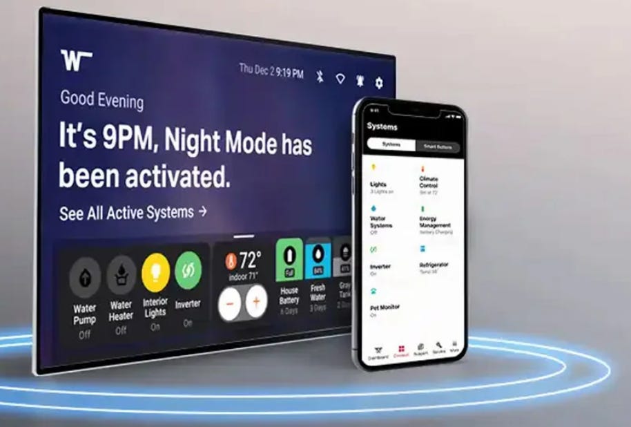
The platform offers features such as smart notifications, GPS tracking, remote climate control, and smart energy management. Ron Totton, KORE president and CEO, said the platform empowers RV owners to travel with confidence and convenience.
Contact: Stephen Rana, Kore Wireless, sbell@korewireless.com, www.korewireless.com.
Trimble Debuts Forestry One Platform to Modernize Timber Operations
Trimble TRMB 0.00%↑ has launched Forestry One, a cloud-based software platform designed to connect and streamline workflows across the forestry supply chain. The platform aims to enhance visibility, decision-making and productivity from planning to harvesting. Forestry One consolidates multiple tools into a single solution, offering real-time collaboration for landowners, managers and contractors, the company said. Forestry One allows end-to-end timber tracking that tracks timber movements from the forest to the mill, the company said.
Contact: Trimble, www.trimble.com.
STMicroelectronics Launches Miniature AI Sensor for Smarter Wearables and IoT Devices
STMicroelectronics STM 0.00%↑ has unveiled a compact, AI-enabled sensor that integrates activity tracking and high-impact event detection for personal electronics and IoT applications. The new LIS2DUX12 and LIS2DUXS12 sensors combine a three-axis accelerometer with a finite state machine and machine learning core to deliver efficient on-device intelligence, the company said.

Designed for ultra-low power consumption, the sensors are optimized for use in fitness trackers, smart wearables, and wireless sensor nodes. ST says the sensors are currently in production and available for order.
Contact: Alexis Breton, STMicroelectronics, 33 659167908, alexis.breton@st.com, www.st.com.

Create a FREE ManyMe Account.
TwoNav Launches Outdoor Navigation App
TwoNav has launched its TwoNav 6 outdoor navigation app. TwoNav 6 features an editor that allows users to create routes, itineraries or modify the layout of an existing route, the company said.
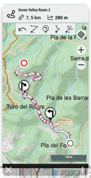
The TwoNav Premium and Pro subscriptions include OpenStreetMap routable map with worldwide coverage. Other map features include urban roads, mountain trails, rivers, peaks, and key points of interest for each country, the company said.
Contact: Santiago Twose, TwoNav, stwose@twonav.com, www.twonav.com.
SeRo Systems Launches Real-Time Display to Detect GPS Jamming and Spoofing
SeRo Systems has introduced a new real-time GNSS Radio Frequency Interference (RFI) Situation Display to monitor and detect GPS jamming and spoofing threats. The display provides live analysis of RFI events, offering users immediate visibility into signal disruptions across the globe, the company said.
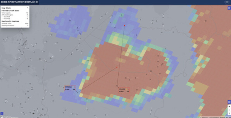
It supports multiple use cases, including aviation, defense, and critical infrastructure protection. The technology aims to enhance situational awareness and enable faster responses to interference incidents, the company said.
Contact: SeRo Systems, www.sero-systems.de.
Bluedot Enables Charging Experience for Rivian’s Service Fleet
Bluedot announced it is now powering the charging experience for Rivian’s service fleet across the United States. The integration provides Rivian with a streamlined solution for locating, charging, and managing electric vehicle charging sessions. Bluedot’s platform offers features such as real-time charger availability, automated payments, and energy cost tracking. The collaboration aims to enhance operational efficiency and reduce downtime for Rivian’s service vehicles.
Contact: Bluedot, fleet@thebluedot.co, www.bluedot.co.
Teledyne to Showcase Underwater Surveillance Tech
Teledyne Geospatial is participating in the SeaSEC Challenge Weeks in the Netherlands, showcasing its technology for securing undersea infrastructure. The event, running from May 12-23, demonstrates expertise in underwater surveillance.
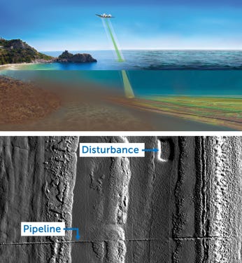
Teledyne Geospatial, along with Teledyne Marine and Teledyne FLIR, will demonstrate a rapid method for underwater surveillance. This method uses an airplane equipped with airborne lidar and CARIS software, providing high-speed, high-resolution underwater surveillance that is 45 times faster than traditional methods.
Contact: Jennifer Parham, Teledyne Geospatial, jennifer.parham@teledyne.com.

Click HERE to Join our growing Location Business News LinkedIn Group!


